
Okay, this isn’t about biking, but it is a carfree adventure, so I think it belongs. If you’re in Portland and haven’t ever explored the 4-T Trail, it’s probably time.
What is the 4-T trail, you ask? Well, it’s a multi-modal loop that takes you around some of the loveliest places in Portland with some of the loveliest views. It hits downtown Portland, the Oregon Zoo, Council Crest (one of my favorite parks in Portland), the tram to OHSU (Oregon Health and Science University, that is;) with its amazing views of the city, and the South Waterfront, to name a few of the highlights.
“4-T” refers to the four methods of transportation you will use to complete the loop: the train, trail, tram, and trolley. Yes, the “trolley” is actually called the streetcar, but that messes up the T theme now, doesn’t it? And it is rather trolley-esque.
So how does it work? Basically, you can start the loop at any point and go in either direction. Here’s a map I nabbed from the 4-T website for a visual to start with:
 (thanks, 4t-trail.org!:)
Let’s say you start downtown. You’ll get on the MAX (the train–yellow on the map) and take it up to the Oregon Zoo. There, you hop onto a lovely hiking (t)rail, green, that takes you about 4 miles over to OHSU. It’s a little hilly, which makes sense since you’re walking through the West Hills, but it’s totally worth it. Not only when you get to Council Crest, arguably the highest point in Portland and a lovely spot for a lunch stop, but also when you get to OHSU. First of all, it’s rad just to walk around the campus there–its remote location means that unless you’re hospitalized or a med student, you probably haven’t spent much time there, and it’s lovely–but since it’s up on the hill it also offers astounding views of Portland, the Willamette River, Washinton, and all the Cascade Mountains you can see from here.
From OHSU, you take the aerial (t)ram, the best 3-minute transit trip you will ever take.
 (yep, that’s the space-age tram, with the south waterfront condos near the river and Mt Hood in the distance. And this is what it looked like on Saturday. So awesome!:)
The tram deposits you on the South Waterfront, where you can hop on the streetcar–er, the trolley–to take you back to downtown Portland.
The whole thing is very well signed, so even on the trail portion or between different transit options you don’t really need to worry about getting lost. Just follow the signs with the 4-T logo on them:
 (my Saturday hiking buddies on the hike potion of the trail, mugging by one of the easily-understood 4-T routefinding posts:)
I’ve done the 4-T trail twice now and started in different places both times–first at the South Waterfront, then this weekend at the zoo. I don’t think it really matters where you start; I’d recommend starting somewhere where you also want to finish. So if you want to, say, go out to eat at the end of it, start downtown near the restaurants; if you want to start somewhere that’s easily bikeable and that has a whole bunch of bike parking available, start at the South Waterfront.
What does matter is which direction you take on the loop. I’m sure they’re both equally lovely, but if you go down the tram, it’s free. If you go up, it costs $4. For that reason, if you’re looking at the map, I’d recommend going counter-clockwise.
One last thing to consider. The tram has limited hours. I say this only because the first time I attempted the loop, we got almost all the way to OHSU before we saw a sign indicating that the tram would not be running anymore by the time we got to it. So we had to find an alternate hike back down to the South Waterfront where our bikes were waiting for us. Which was actually kind of fun for me (unexpected adventure, yay!:), but I could imagine it being less so if it were the end of the day and you were, for example, hiking with kiddos who were ready to be done. You can find the tram schedule here.
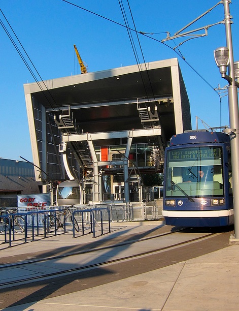 (two of the four Ts–the trolley, and the tram terminal–at the South Waterfront. Notice all the bike parking possibilities!:)
The whole thing can take anywhere from a few hours to all day, depending on how long you spend lollygagging at any various stop. I think it makes for a really fun day trip, just remember to take the tram schedule into consideration. And to make it truly car-free, why don’t you try biking to wherever it is you decide to start? :)
I really like the 4T. Reminds me that I haven’t done it in awhile. I think the best part of the whole concept of the 4T is that it has brought attention to the Marquam Trail, which up until now was the forgotten, lesser trail of the West Hills. (Wildwood would be the “greater” trail.) While the Wildwood is more of a woodsy experience and is further away from civilization, it’s harder to do a long hike, as once you get away from Balch Creek it gets further from transit options. Marquam doesn’t have that same “out there” feel, as you’ll see houses and cross roads, but you have more “bail out” options if need be. Now if they could just work on grading that section from Patton Road to the Zoo…