
I never did take a big bike trip this year — which I’m not really so sad about, given the circumstances, though maybe a little sad. I still had some pretty good adventures in a stupid and crazy COVID year, so I feel pretty thankful about that, lose-myself-in-the-wilds bike trip or no.
But I DID want to sneak in at least some sort of “bike trip” this year, even if it wasn’t a super extended one where I travel from town to remote town and camp who knows where forget about time for weeks on end. And I kind of wanted to stay maybe in one of the coastal State Park cabins or yurts — somewhere indoors for this cold and wet and dark time of year — but those were all closed still. So I sucked up the more expensive AirBnB option, and biked myself out to the coast for a few days.
.

(my bike! the coast!)
.
I’d never biked to Manzanita before, and it’s somewhat awkwardly placed along the coast if you’re trying to find a straight shot from Portland. (Spoiler alert: there is no straight shot from Portland.)
So with a few options, none of which seemed particularly better than the other, I didn’t really decide on a route until the day before I left. Utimately, however, I decided to ride out on Highway 26, which is not one of the recommended bike routes from Portland to the coast (see more here on recommended Portland-Coast bike routes, or combining your bike trip with bus transit).
It’s not recommended because it doesn’t have great shoulders all the way AND it has a lot of traffic, but I decided to take it — part way, I mean — because I wanted to take Nehalem River Road south from it without having to take the super long way coming through Mist and Jewel (which would have turned a 87 or so mile day into a 117 or so mile day).
.
(the overall route. My westward route is on top, eastward is on bottom)
.
It was a calculated risk, and it worked out just fine: only the last few miles that I was on Highway 26 did I lose the mostly nice shoulder, and at that point I was going downhill, so it went by fairly quickly. I don’t think I would recommend biking past Elsie on 26, though, and I’m not sure I’d want to head east from Elsie up the hill, although I did think about it for half a second until I decided not to. Eh, and if it were a super nice weekend where half of Portland goes out to the coast, I don’t think I’d take it then either, even at all.
.

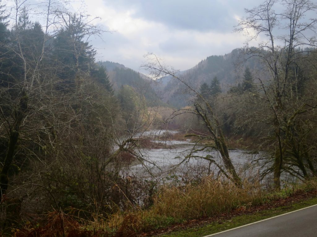
(Nehalem River Road at Cronin Creek)
.
But for this trip, it was worth it for Nehalem River Road, which is totally lovely in (almost) every way although unpaved for many miles. I happened to hit it exactly when there were two dudes out regrading it — i.e. dumping a whole bunch more thick gravel on it — which made it fairly grueling and sometimes untenable for my little not-so-fat-tired bike to bike through. It was also a lot hillier than I expected it to be. So, it was a little more tiring that I expected, but, again, super lovely, along the Nehalem River the whole time, with almost no one else on it.
.

(the weather was much nicer than I was expecting, too!)

(confluence of the Nehalem and Salmonberry Rivers)
(more Nehalem River, after the pavement came back again)
.
Despite the unexpected lack of pavement and hilliness, I still made it to Manzanita by 3:30 or so, which was my goal: get there while it was still light out and I could see the ocean.
And once I was there, I had a few days to play. I’d opted to stay right near the south Neahkahnie Mountain trailhead because I wanted to be able to run and hike on trails without having to bike to them, although I was a little worried that I would feel sort of isolated being up a big (and shoulderless) Highway 101 hill from Manzanita and the ocean. But it ended up being just fine, since I could cross the highway and then sneak through another neighborhood down to the ocean (about 2 miles away–bikeable or walkable if I was into a hike:)
It was a very sweet stay, and my AirBnB was perfect, and I will not advertise it because I want to keep it all for myself (ha!) but I will be happy to tell you about it if you ask me.
.

(near the trailhead near my house:)
.
To get home, I decided I didn’t want to ride Foss Rd/Nehalem River Road with all its deep gravel or any parts of Highway 26 again, so I went down the coast to Tillamook, where I got on Highway 6 back to Portland.
.

(the way down Highway 101 was nicer than I expected, with more shoulder to bike in than I expected too! I also saw a LOT of bald eagles, harbor seals, and elk!)
.
Highway 6 is very pretty, following the Wilson River basically the whole time, but it’s definitely not peaceful. Especially on a very rainy day, when car tires are so much louder on the wet roads. So I enjoyed the scenery, but could have done without the cars. Also, I hadn’t really thought about this, but when I biked west on Highway 6 way back in the day, I think the only time I’d previously biked on this road, I had this feeling of going downhill forever to get to Tillamook. That’s because it’s true, it’s like 30 miles of hill between Tillamook and the Coast Range summit. It’s never particularly steep, but it makes things just hard enough that after an hour or two it really feels like you’ve been slogging up forever. Or maybe that was just me: I’d broken an integral part of my back fender, so it was consistently rubbing on my tire — meaning that I was permanently semi-braking. So, I was definitely ready to be done with hills by the time I finally made it to the damn top (ha! Which is only slightly higher than 1600ft)
.

(I took zero pictures from my ride on Highway 6, since it started raining on me just as I left Tillamook and didn’t stop until like two days later. ha! So this is from an earlier day wandering at Nehalem Bay State Park)
.
A note: Perhaps you noticed that my map started and ended in Hillsboro, not Portland. This was the first time I’ve used public transit since COVID, taking the MAX from Goose Hollow out to Hillsboro to cut out the part through the West Hills. On the way out, I decided that I would give it a try: I was leaving super early and going the opposite direction than I imagined most people would be going, so I figured it might not be too bad. Sure enough, there were only very few of us on the train, and everyone wears masks, and the doors open and recirculate air every few minutes — it felt fine.
I still wasn’t sure I would take it on the way back, but by the time I got to Hillsboro that evening, I was kind of ready to be done riding (except for the last 6 miles home from the MAX in Portland, I mean:) And it was even emptier on a very rainy, dreary Saturday evening than it was on a very early Monday morning. So, I’m not really ready to take transit as a matter of course, but it worked out pretty well for this trip.
.

(biking in the time of COVID)
.
It was really nice to sneak in a few days of winter bike travel this year, and experiment with different ways to get to/from the coast. I don’t really love either of the ways I took, but they were both totally servicable and felt safe enough — the pragmatic choice if you’re heading mid-coast and want to bike the whole way. I had a good time both directions (though maybe slightly more so when it wasn’t raining on me and my fender wasn’t broken;) and would feel okay doing either again. And it’s always nice to remember that this sort of thing is possible with a few days off. Oregon is great:)
Very nice! I haven’t biked to the Coast since 2017. I did that long way that you mentioned (B-V/47/202/103/Nehalem River Rd). I thought the Nehalem River Rd was nice but definitely hillier than expected. If I remember correctly the hilliness starts after you cross the Salmonberry, and those hills were short but steep.
As for cabins, Emee and I booked one at Fort Stevens for after the New Year. This’ll be the first New Year since 2006 that I’ve spent in the city. We were hoping to book it for the holiday, but they were booked until Saturday the 2nd. That’s okay. This’ll be the first time I’ve stayed in Fort Stevens, as I tend to stay at Cape Disappointment instead. (Heck, I don’t think I’ve even set foot in the park since 2001!) And the cabins are “deluxe”, which are more expensive, but have microwaves, fridges, and bathrooms with showers!
We looked into Cape Lookout, but the lodging is booked solid. And many of the other yurts/cabins on the coast are still closed.
Oooh! When you biked out that way, did you camp in the middle somewhere? (Just cuz that seems like a loooong ride, and I always wonder about good camping between here and the coast — I’ve never actually stayed in the middle anywhere).
Have fun at Fort Stevens! That was one of the places I tried to stay when I went out, but they weren’t available then, alas. heh. I too was intrigued by the “deluxe” — You’ll have to let me know how it goes:) (I kind of love the jetty out there and the magical mixing of Columbia and Pacific. Which I know you get at Cape D too, but is magical either way:)
Happy new year!!:)
I camped at Vernonia when I did that trip. But wait, you don’t remember my report from 2017? ;-)
https://urbanadventureleague.wordpress.com/2017/06/01/a-tour-to-the-coast-may-20-23-2017/
I’m surprised you didn’t take Nestucca River Road out of Carlton and into Beaver. You can avoid highway 47 through Gaston/Yamhill by taking Spring Hill Rd to the east.
I actually did think about it, but it added something like 25 or 30 miles, which seemed like a lot for an already 90+ mile day:) Maybe next time when there’s more daylight:)